Table of Contents
- What the Corps Is Actually Studying
- The 9,300 cfs Figure Is Not a Buford Dam Release Target
- The Counterintuitive Case for Dredging Efficiency
- Lake Lanier's Operating Framework
- Why Shallow-Cove Properties Face Asymmetric Risk
- What Buyers Should Evaluate Before Purchasing Waterfront Property
- The Timeline and What Comes Next
- Conclusion: Informed Ownership Starts with Accurate Information
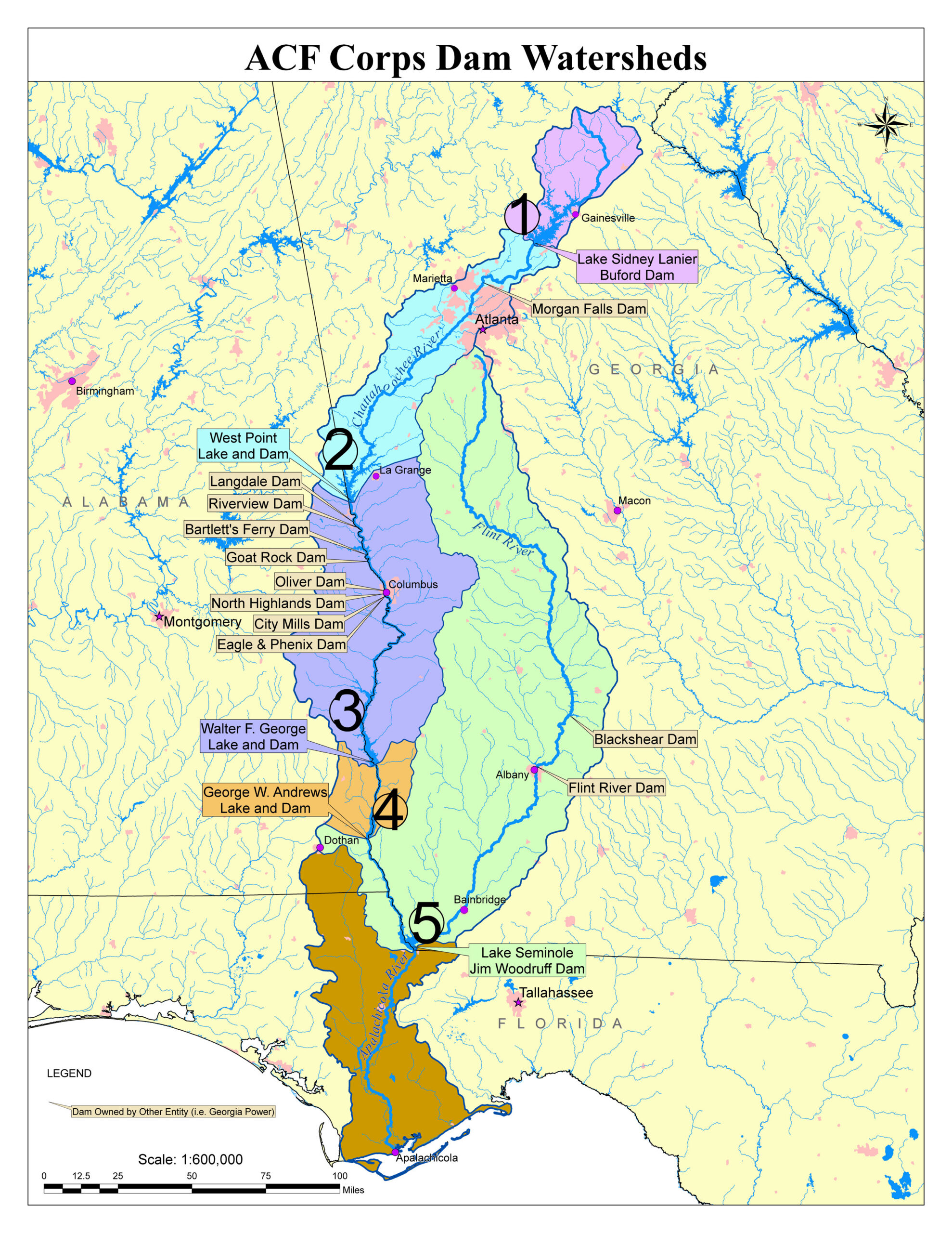
The U.S. Army Corps of Engineers is not proposing to dredge Lake Lanier. That sentence alone clears up most of the confusion circulating in North Georgia real estate circles right now. What the Corps is studying is whether to resume maintenance dredging of the federal navigation channel in the Apalachicola-Chattahoochee-Flint (ACF) River Basin, hundreds of miles downstream. But because Lake Lanier and Buford Dam are upstream nodes in that same federal water-management system, the study carries real, if indirect, implications for the Lake Lanier water level and for anyone who owns or is buying waterfront property here.
This article explains what the Corps is actually doing, what the 9,300 cfs figure really means, and why the impact on shallow-cove properties is the most underreported dimension of this entire conversation.
What the Corps Is Actually Studying
In September 2026, the Corps published a formal Notice of Intent to prepare a Supplemental Environmental Impact Statement (SEIS) for the potential resumption of operations and maintenance dredging along the ACF navigation channel in Georgia, Alabama, and Florida. No final decision has been made. The public comment period closed September 28, 2026, and the draft EIS is expected for public review in spring 2027.
The ACF system is a connected chain of reservoirs and rivers managed for multiple purposes: flood protection, hydropower, water supply, recreation, and commercial navigation. The Corps’ Mobile District manages five federal reservoir projects within the basin. Lake Lanier, impounded by Buford Dam in Forsyth and Hall counties, sits at the northern end of that chain.
For a fuller picture of how the Corps manages the ACF system as a whole, the ACF River Basin page at the Mobile District lays out the multi-purpose framework that governs Buford Dam’s operations alongside every other federal project in the basin.
The 9,300 cfs Figure Is Not a Buford Dam Release Target
A specific flow figure, 9,300 cubic feet per second, has appeared repeatedly in public discussion about this study. It deserves a precise explanation, because misreading it leads to real panic among lakefront owners.
That number represents a downstream flow condition in the navigation-channel analysis, not a proposed release rate from Buford Dam. By the time water reaches the lower ACF navigation channel, it has collected runoff from an entire multi-state watershed, including contributions from multiple tributaries, rainfall events, and releases from several federal reservoirs. Buford Dam is one upstream input among many.
Attributing 9,300 cfs directly to Lake Lanier is like reading a river gauge at the mouth of a river and blaming a single headwater lake for everything it measures. The Corps’ public briefing on the ACF dredging study confirms that the EIS process is still underway and that modeling of specific operational alternatives has not been finalized.
The Counterintuitive Case for Dredging Efficiency
Here is an argument that rarely surfaces in online discussions about this study: a restored, deeper navigation channel may actually require less downstream flow to maintain navigable depth than a sediment-filled channel does.
“Dredging does not automatically mean more water has to be released from Lake Lanier. A restored, deeper navigation channel can potentially achieve navigable depth with less downstream flow than a sediment-filled channel.”, HomeOnLakeLanier_Lake_Lanier_Dredging_Explained
This reframes the entire risk calculus. If the Corps ultimately selects an alternative that restores channel depth, the system might sustain navigation with lower required flows than the current degraded channel demands. The relevant comparison is not dredging versus no dredging in a single snapshot. It is the total water demand of the proposed navigation operation over the full operating season versus what current operations require.
That said, an important uncertainty remains. As Team Giarraffa’s analysis of this study notes: “The question that remains unanswered is whether a restored channel would also support a longer or more reliable navigation season and, if so, what the net effect would be on reservoir operations throughout the ACF Basin.” A longer season could offset the per-day efficiency gain. That answer will not be available until the draft EIS is published.
Lake Lanier’s Operating Framework
To evaluate any downstream scenario, you need a baseline for how the Corps already manages the Lake Lanier water level. The targets are specific and seasonally adjusted:
Summer conservation pool target: approximately 1,071 feet above mean sea level
Winter conservation pool target: approximately 1,070 feet above mean sea level
Record low: approximately 1,050.79 feet, reached in December 2007, roughly 20 feet below full pool
The 2007 low is historical context, not a baseline expectation. It resulted from a severe multi-year drought compounded by competing downstream demands. But it illustrates how far the lake can drop under stressed conditions, and it is the right mental anchor for evaluating worst-case scenarios tied to any change in basin operations.
The Corps does not operate Buford Dam in isolation. Every release decision weighs flood risk, downstream flow commitments, power generation, and the conservation pool simultaneously. Any alternative selected through the SEIS process would be layered into that existing framework, not replace it.
Why Shallow-Cove Properties Face Asymmetric Risk
The Same Number, Very Different Consequences
A one-foot drop in Lake Lanier water level registers identically on the Corps’ gauge regardless of where your dock sits. The practical consequences, however, diverge sharply based on the water depth at your specific property.
Team Giarraffa’s analysis of this study puts the asymmetry plainly: “A change in lake elevation doesn’t affect every waterfront property equally… At the shallower property, that same change could affect boat draft, propeller clearance, a boat lift, submerged hazards, dock positioning, or the controlling depth between the dock and open water.”
A dock sitting over 25 feet of water loses one foot of clearance and the owner barely notices. A dock sitting in a cove with five or six feet of usable depth may lose boat-lift function entirely, or lose navigable access to open water through a shallow channel. Those are categorically different outcomes, even though the gauge reading is identical.
Frequency and Duration Matter as Much as Depth
Most discussions of lake-level risk focus on the absolute low. That framing misses something important. As the Team Giarraffa analysis observes: “The analysis should therefore consider not only how low Lake Lanier might go, but how often, for how long, and during what part of the year.”
Two days below a critical threshold in January is a minor inconvenience. Six weeks below that same threshold during June, July, and August is a summer lost. For shallow-cove owners, the frequency and seasonal timing of low-water events is the number that actually determines whether the dock is usable during the season that matters most.
The draft EIS, when it arrives in spring 2027, should model these operational patterns across proposed alternatives. Until then, the risk to any specific property remains unquantified.
What Buyers Should Evaluate Before Purchasing Waterfront Property
The ACF dredging study has not changed the fundamentals of waterfront due diligence on Lake Lanier. It has, however, raised the stakes for buyers who skip the depth analysis. Before closing on any lakefront property, a serious buyer should verify:
Water depth at the dock and along the access channel to open water, measured at or near the current conservation pool level, not at high water
Cove geometry, including whether a shallow bar or sill separates the cove from the main lake at lower pool elevations
Dock permit status, including whether the permitted structure is appropriate for the actual water depth at the site
Historical low-water access, specifically whether the property was usable during the 2007 drought or the 2011-2012 dry period. We need to keep in mind, the extreme low water levels in this case are more of an anomaly as are our current water levels due to extreme drought conditions and maintenance on the Buford Dam this year.
Boat lift specifications relative to the site’s minimum usable depth, not its maximum
A permitted dock is a legal asset and a valuable one. But as Team Giarraffa’s analysis puts it: “A permitted dock is valuable, but usable water is what makes the dock useful.” The permit does not guarantee depth. The depth is a function of the cove, the shoreline grade, and where the lake sits on any given weekend in August.
Buyers evaluating luxury lakefront homes on Lake Lanier should treat water-depth verification as a non-negotiable step in the inspection process, not an afterthought.
The Timeline and What Comes Next
The SEIS process follows a defined sequence under the National Environmental Policy Act. The key milestones to track are:
Public comment period on the Notice of Intent: closed September 28, 2026
Draft EIS release: expected spring 2027
Public comment period on the draft EIS: dates to be announced
Final EIS and Record of Decision: timeline depends on comment volume and agency review
No operational changes to Buford Dam or Lake Lanier management will occur until a Record of Decision is issued and any selected alternative is implemented. That process typically takes years, not months. Property owners have time to follow the draft EIS carefully and, if warranted, submit comments during the next public comment window.
The Lake Lanier Resource Guide maintained by Team Giarraffa includes contact information for the relevant agencies and marinas, which is a practical starting point for anyone who wants to stay current on Corps announcements.
Conclusion: Informed Ownership Starts with Accurate Information
The ACF dredging study is real, the process is active, and the indirect connection to Lake Lanier water levels is worth understanding. But the study is not a proposal to drain the lake, and the 9,300 cfs figure is not a Buford Dam release order. The actual risk, if any materializes, will be distributed unevenly across the lake. Deep-water properties will absorb it differently than shallow-cove properties, and the draft EIS in spring 2027 is the document that will finally allow that risk to be quantified.
For buyers and current owners alike, the practical response is the same: know your water depth, know your cove, and do not rely on a dock permit as a proxy for usable access. The Lake Lanier water level is managed within a framework that has held the lake within a relatively narrow operating band for decades. Understanding that framework, and how the ACF study might interact with it, is the foundation of sound waterfront ownership.
Team Giarraffa works exclusively in the Lake Lanier market and brings data-backed analysis to every waterfront transaction across Forsyth, Hall, Dawson, Gwinnett, and Lumpkin counties. Browse the current luxury lakefront listings on Lake Lanier to see what is available, or visit the Team Giarraffa blog for ongoing coverage of market conditions, Corps updates, and the lake-specific due diligence questions that matter most to serious buyers.
Frequently Asked Questions
Is the Army Corps of Engineers planning to dredge Lake Lanier?
No, the U.S. Army Corps of Engineers is not proposing to dredge Lake Lanier itself. They are studying the potential resumption of maintenance dredging for the federal navigation channel in the Apalachicola-Chattahoochee-Flint (ACF) River Basin, which is located downstream from Lake Lanier.
What is the 9,300 cfs figure mentioned in relation to the dredging study?
The 9,300 cubic feet per second (cfs) figure represents a downstream flow condition for the navigation channel analysis in the ACF River Basin, not a specific release target from Buford Dam at Lake Lanier. This number accounts for water from multiple sources, and attributing it solely to Lake Lanier is a misinterpretation.
How might dredging efficiency affect Lake Lanier’s water level?
A restored, deeper navigation channel could potentially require less downstream flow to maintain navigable depth compared to a sediment-filled channel. This suggests that dredging might not automatically lead to increased water releases from Lake Lanier, though the net effect on reservoir operations is still under study.
How does the Lake Lanier water level affect shallow-cove properties differently than deep-water properties?
A change in lake elevation impacts shallow-cove properties more significantly. While a one-foot drop might be barely noticeable for a deep-water dock, it could affect boat draft, propeller clearance, or even render a shallow dock unusable for accessing open water.
What should buyers evaluate before purchasing waterfront property on Lake Lanier?
Buyers should verify water depth at the dock and access channel, assess cove geometry for potential shallow bars, check dock permit status against actual depth, and investigate historical low-water access. Usable water access is critical, not just the existence of a permitted dock.